Journey to the Border Wall
- By Sarah A. Leavitt and Marla R. Miller
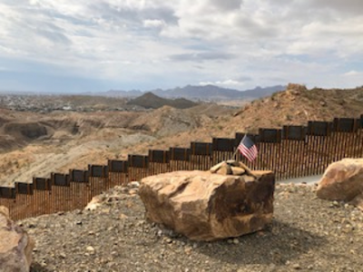
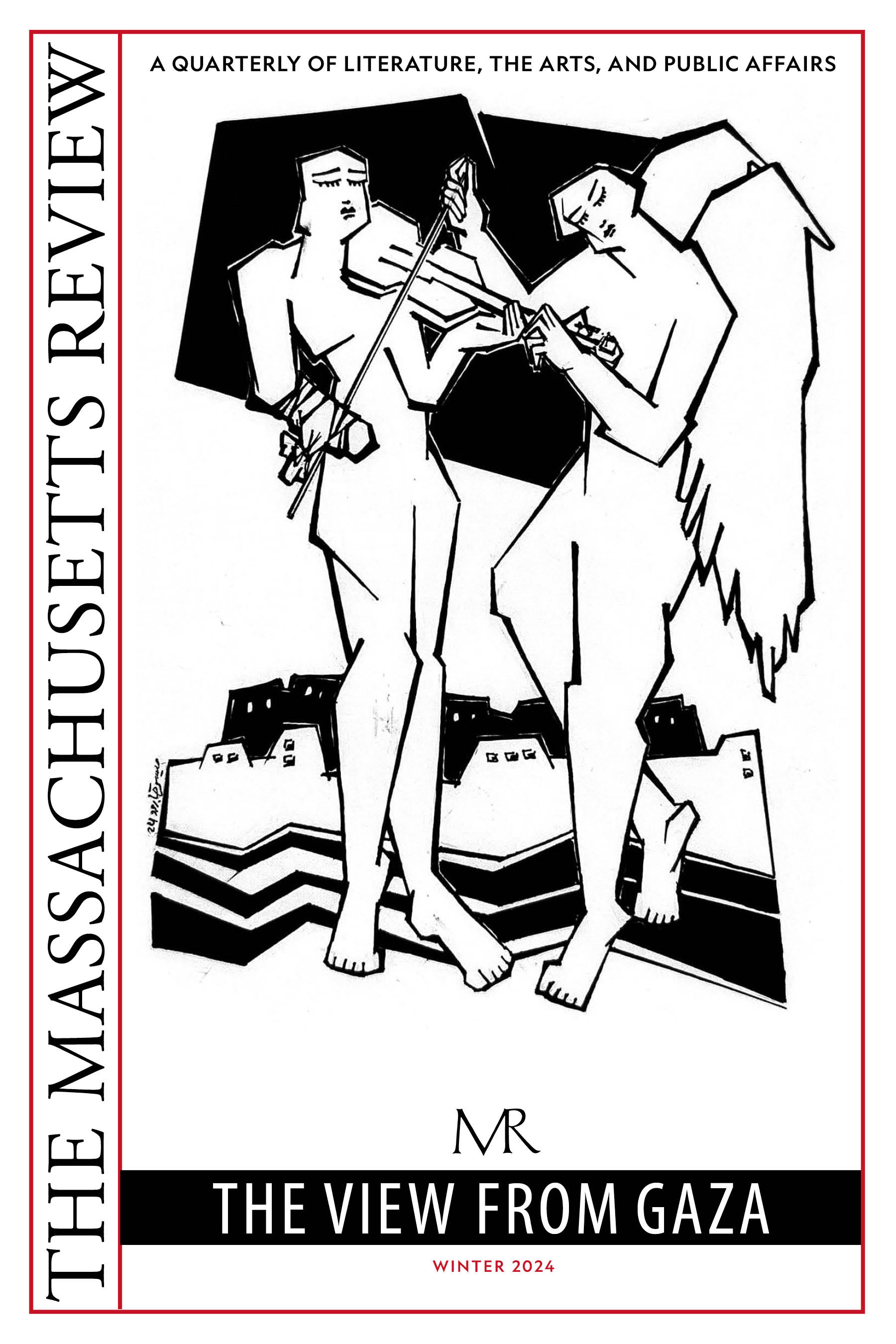
Photo: The Rio Grande Valley from Mount Cristo Rey, alongside the "GoFundMe" border wall.
Almost immediately after landing at the airport, we changed all of our plans. We had a long list of museums to see and people to talk to as we embarked on our borderlands journey to West Texas, but almost as soon as we deplaned all of that seemed wrong. We were here to see the wall, and we should start by seeing the wall.
We hoped to experience, for a minute, what it was like to live in the shadow of the border wall. We wanted to feel the surveillance and think about how to translate some of that feeling into accessible content for college students and museum visitors at our respective jobs. And we had to start somewhere. We are trained as historians, but this time we started with the very newest thing, with President Trump’s promised “big, beautiful wall.” After that we’d work backwards, to try to figure out how we got here.
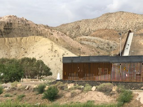
The "GoFundMe" border wall, and Rio Grande
As traditional research trips go, this one was a bit unconventional—we had only the barest sketch of an itinerary. Our September 2019 trip, prompted by exhibition planning at the National Building Museum, was intended to spark conversation, to build a visual vocabulary, to see with our own eyes some of what is happening, and to help us think about how to tell a story about the border that feels honest, one that honors the people who live this crisis every day. If it is true—as we believe it is—that museums and public history efforts have the responsibility to explore relevant stories and lead students and visitors to productive action as world citizens, then we had to make this trip. We could not present these subjects to others without first talking to people, looking, and listening. We needed to see and hear for ourselves, to sit with what we would learn, and gain the broader perspective that only comes from being there.
The newest section of the border wall between the United States and Mexico was constructed on private land, after more than 250,000 donors gave over $25 million through an online crowdfunding platform. A year later, the organization now faces a series of criminal charges with allegations of fraud and embezzlement, but at the time its leaders convinced donors that private construction, unconstrained by environmental or eminent domain regulations, could proceed faster than the federal government, which has been slow to build new barriers, despite the President’s promises. In a particularly wry twist, this new half-mile screen of steel slats in Sunland Park, New Mexico sits right next to one of the nation’s oldest boundary markers, erected where the Rio Grande turns north into New Mexico. So the oldest and the newest border markers exist in the world together, standing alongside yet in sharp contrast to one another, laying bare the changes in our relationship to Mexico, to immigration law, and to nationalism.
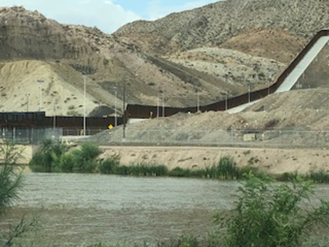
The border wall visible through a rollercoaster at Western Playland. Sunland Park, NM
This new wall was harder to find than one might think, given that the thing is over twenty feet tall and runs up New Mexico’s Mount Cristo Rey (our Ph.D.s are definitely not in wayfinding). Eventually, though, we realized that the wall we had been following for miles, snaking up in the distance, was the wall, the one we were looking for. This revelation wasn’t as useful as we had hoped, since we weren’t exactly sure how to navigate the highways and dirt roads that intersect with it only sporadically. We drove in circles—frustration made more harrowing as we passed the same Border Patrol vehicles over and over again, with agents inside staring right through us (and probably running our license plates). Acutely aware of our privilege as white women in a rental car, we nevertheless felt (perhaps irrational) fear and trepidation as we continued to drive on.
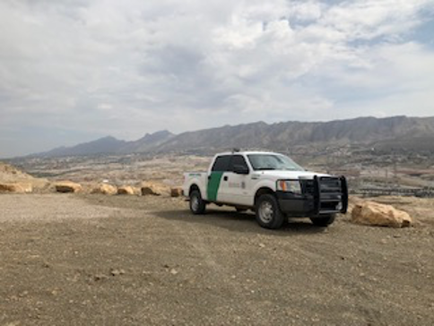
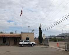
US Customs and Border Protection atop Mount Cristo Rey
Eventually we pulled over. Surely there had to be a better way to find our destination. Google located a news report with an accompanying photo that showed the wall standing near a small white obelisk. As veteran seekers of monuments and markers of all kinds, we knew this was the clue we’d been looking for. Imagine, then, our delight to discover that this object was in fact International Boundary Marker #1, installed in January 1855, the first in a chain of markers distributed across two thousand miles of a border newly established in the wake of the U.S.-Mexican War. Finding this 12’x5’ stack of marbleized concrete instantly became a quest.
We thought we’d finally found the direction we needed, but our hopes were dashed quickly: though the marker had once welcomed visitors with signs and a parking lot, that information was apparently months out of date. Now there was no parking lot. There wasn’t even an accessible road. “WARNING!! IMPORTANT UPDATE!!” read one of the websites, offering dire tales about the significant risks involved in trying to see the nineteenth-century marker, which sits south of the Rio Grande and thereby (sort of) in Mexico. U.S. nationals are supposed to be allowed access to the marker, which, after all, was erected in a flash of binational cooperation during the surveying project of the 1850s. But some websites cautioned that visitors who accidentally crossed into Mexico had been jailed, fined, and delivered (days later) to U.S. Border Patrol for further action.
Boundary Marker #1 alongside the "GoFundMe" border wall
So we kept driving around in circles, struck by how being here was both overwhelming and mundane. Sunland Park, New Mexico is a suburb of El Paso, filled with strip malls, gas stations, and Tex-Mex restaurants. There’s a Target, and a crossfit studio. The wall loomed in the distance, beyond yet strangely visually entangled with the roller coaster of Western Playland. Yet if for a minute you could forget about how that wall was a twenty-foot tall symbol of xenophobia sunk seven feet into the earth, and if you could ignore the part about how it drove migrants to try their luck—and risk death—at more dangerous crossings in the desert, and if somehow you could block out the nasty us/them rhetoric that puts migrants’ lives in real peril every day, if you could put a pin in all of that (which you can’t, and certainly shouldn’t), it actually looked for all the world just like the barriers lining the D.C. beltway or Interstate 95, built to keep noise down for the neighbors. It is at once ominous and terrifying, and also it simply continues the line of a wall that has been there for decades, and is part of the ordinary borderplex of the U.S. Southwest.
Unable to find any way to access the barrier or the marker safely, we decided to try official channels. Remarkably, after all that pointless driving, it was relatively easy to find the phone numbers for the offices of the International Boundary and Water Commission, which holds our government’s permanent access to the boundary marker. Our query was passed from one employee to another, and finally landed in the Public Affairs office. It was early on a Thursday afternoon when we launched the request, but by the time we finally got somebody on the phone to actually hear us out, it was almost 5pm and, so sorry, but the staff had left for the day, there was nobody there who could make the 5-minute drive from the office, it was too late, so sorry. Would we like to make an appointment for next month? We decided to cross our fingers and try again on Monday.

The next few days were a whirlwind. We toured the National Border Patrol Museum, which celebrates the history of the agency and its weapons, uniforms, and operations. We visited the Chamizal National Memorial, a monument (conversely) to international cooperation. The interpretive whiplash of El Paso is overwhelming, with sites celebrating the policing of the border, the peace at the border, and the commerce of the border as if there is no conflict between these poles of understanding.
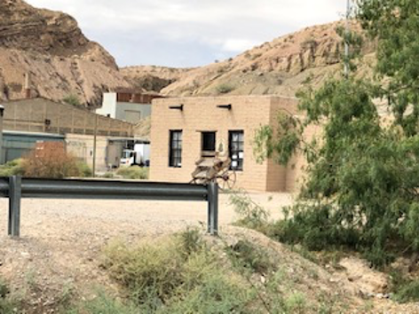
Casa de Adobe, a historic house museum in Juarez, alongside the border at Boundary Marker #1
We shadowed an attorney for a day and got the tiniest glimpse of what it is like to carry around the weight of peoples’ lives on your shoulders, when there are not enough people to help. We met a volunteer lawyer who had just taken the bar and had driven down from Chicago to write briefs for a few months—to do anything, he said, to participate in the effort to assist refugees and migrants. We visited a detention center in El Paso (where we were prevented from taking either notes or photos). We watched the attorney file forms and requests, then inquire about lost paperwork with detention center desk staff who talked about a lost migrant as if she were only lost paperwork, instead of a lost person. We met migrants in orange jumpsuits wearing ankle bracelets while sitting on cold, hard metal benches in the tiny, locked, white rooms—the paperwork, jumpsuits, bracelets, benches, and locks each additional physical manifestations of the border, beyond the concrete and steel of the wall itself. We walked across the Bridge of the Americas to Juȧrez and listened, in concern and sorrow, as applicants for asylum made their—probably futile—cases.
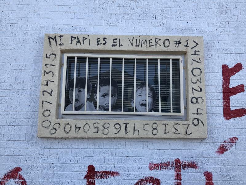
Artwork outside Las Americas Immigrant Advocacy Center
We watched. We scribbled in notebooks and took inadequate photos with our phones, trying to understand some of what is happening at the border. At our border. We stayed up late trying to process what we’d seen. Fear permeated everything. Lost, high on an overpass of the I-10, we were in the U.S. yet also over Mexico, our hearts racing until we found the surface streets of El Paso. If we, as white women of significant privilege, could become so disoriented, it was overwhelming to think about the thousands of stories of the others, with their own relationships to the border, so much more a part of their world than of ours.
But we were unnerved. We looked into the face of a woman who had left her children behind, and who was desperate and scared. We were witnesses to grief, but that was all. We shook her hand, and said goodbye, and walked back across the bridge.
Finally it was early Monday morning—our last day in Texas. We left the hotel quickly, and with purpose. We were determined to see this monument. It’s just an obelisk of stone, but this object from a more distant past felt like an easy thing to understand, since we certainly couldn’t understand anything else we’d seen.
We had a few hours before we had to be back at the airport, and now we had a plan. We drove directly to the Commission office, and knocked on the door. A bemused, uniformed staff member greeted us warmly. He seemed to know who we were: maybe it was our twenty-five early-morning phone messages. “I’m in a meeting,” he said, “I can’t help you.” The monument was so close, we could practically see it from where we were standing. So we pleaded. We are historians, we explained, and from far away. We’ve seen hard things, and now we need to see an easy thing. We need to see this monument.
The offices of the International Boundary and Water Commission in Sunland Park, New Mexico
It was now, for us, a touchstone. It was evidence of a treaty, of the end of hostilities. The marker pierces the land in a way that is less obtrusive, quieter than the border wall, even though the entire purpose of those monuments was to mark land taken in violent conquest. There is something about a white obelisk on any landscape. After centuries of monument making (commemorative and patriotic as well as solemn and elegaic) , this shape in and of itself cues historical reflection, a sense of order and perhaps—whether consciously or not—even national identity. But the obelisks are, of course, no longer the preeminent form of border marking. In the ten decades between 1920 to 2020, an increasingly robust, hardened fence—first chain-link, then razor wire, then steel bollards—both reflected and created international tensions. The nineteenth-century monuments exist as symbols of, at minimum, the work of diplomacy (and diplomats) and a transition from wartime to peacetime. To seek out this simple marker seemed a way to see a different future.
The guy from the International Boundary and Water Commission (who turned out to be named Guy, because that’s how these things go) decided to help us out. It happened to be one of his colleague’s last days on the job, and he had never seen the boundary marker either: so, why don’t we all get into his pick-up, and he’d show us what we’d come to see?
It is possibly ill-advised for two women two thousand miles from home to hop in the back of a truck with two unfamiliar, middle-aged men on a dirt road surrounded by a barbed wire fence. But we had official business, and these were representatives of an official government entity, and we had just met people who were taking actual risks with their lives. This felt safe, in comparison, so we embraced our perhaps misplaced sense of confidence. But then, on a dirt road along the Rio Grande, the truck suddenly pulled over. We weren’t at the monument. We weren’t even on what could safely be called a road. “Want to see something cool?” Guy asked. Clearly, we had lost all sense of time and space and logic. Sure, we said, and we got out of the truck and followed these men we’d just met into the brush.
We were about to go back in time, indeed, though much farther than we’d imagined. We’d started at the most recent piece of border wall, a fence made from giant steel slats that winds up a mountain on private property at the bend of a river, on the border between two states and the border between two nations. We’d wanted to go back 165 years to see an old stone monument. Instead, we went back 65 million years, to some of the first creatures to cross the border, before there were such things as borders. Before there were such things as guns, and laws, and people. We hiked precariously up a mountain—no path, no signs, no evidence of anything, anywhere, and then all of a sudden we were standing in dinosaur tracks. We stood there, the four of us, looking up at the mountains, looking across to Mexico, looking down at the footprints of creatures who crossed this land long before us.
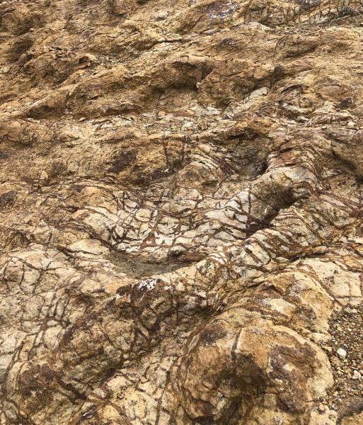
Dinosaur footprints on Mount Cristo Rey
Migration is as old as the hills, as old as time.
We did, finally, see the nineteenth-century monument. We parked a few yards away from Mexican police officers, machine guns slung over their shoulders as they patrolled the bend in the river—and therefore also patrolling the stone marker, with its specially affixed plaque identifying it as an engineering landmark. The marker’s park-like setting was developed in the 1970s; it encompasses an adobe house museum, an attempt to showcase international cooperation in historic preservation. The only cooperation showcased by the current landscape is the agreement between the U.S. and Mexican governments to police border crossings more tightly. Though, between us, we had been to probably hundreds (thousands?) of historical markers, we had never been so close to machine guns. Another new experience. In our photographs, we look wary, as if we are not on a work trip or a vacation, but in some sort of hellscape; as if we had not just triumphed in our quest to see this elusive monument, to which we are guaranteed access as U.S. citizens, but which seemed a little anticlimactic as the harsh morning sun glinted off machine guns in the shadow of the wall.
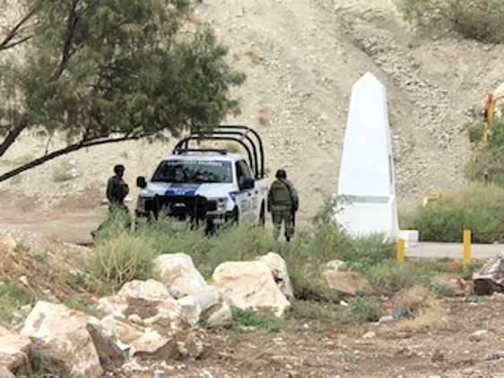
Mexican border patrol next to Boundary Marker #1
We climbed back into the government pick-up truck, but our host had one more surprise in store. Moments later, we were careening up the mountain, on a private, fenced-off road, inaccessible to the public and not at a grade any normal car could drive up, directly alongside the privately funded wall. The menacing slats whizzed past the windows, the gears groaned, and Guy screamed over the wind to us from the front seat, “It’s like a roller coaster!” Our churning emotions, the pit and pitch in our stomachs, agreed: this was true both literally and figuratively. We parked at the top. After a quick conversation with the Border Patrol agent parked up there, because the Border Patrol is always parked everywhere, we each turned to take in the extraordinary view. This agent was specifically monitoring some Mexicans fishing in the river below, and he seemed unconcerned about us, so we looked around, silently, listening to the wind and the cars on the road below, then we sat on a rock to think.
We looked out over the whole of the valley: the Franklin Mountains, the Chihuahuan Desert, and the Rio Grande as it makes its over-engineered, halting way to the Gulf of Mexico. We thought about the Venezuelan migrant at her dangerous shelter, and the HIV+ Cuban migrant who we’d seen at the detention center in El Paso, and who had been processed for release into the U.S. that morning. Where were they now? We thought, improbably, about dinosaurs. And we thought about our broken immigration policy, of the vast tangible and intangible systems that make up the border, only some of which we felt we understood. And then there was a U.S. flag on top of the mountain, waving in the wind, planted in the ground triumphantly, as if this were the moon. We were so far from home, so far from anything that seemed safe, comforting, or familiar. We might as well have been on the moon. Eventually it was time to go.
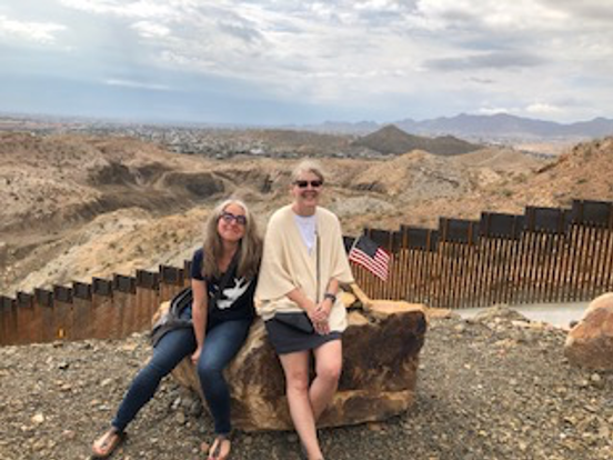
The authors, at the lookout atop Mount Cristo Rey
“What did you do in Mexico?” the Border Patrol agent had asked upon our re-entry over the Bridge of the Americas. “We visited people,” we said lightly, as the lawyer had advised.
What we didn’t say was: “We bore witness. We were changed. We are not the same.”
Sarah A. Leavitt is a former curator of the National Building Museum, Washington, D.C.
Marla R. Miller is a professor of history at the University of Massachusetts Amherst and director of its Public History Program.
All photographs courtesy of the authors.
The authors would like to thanks Liz Ševčenko for her thoughtful reading of an early draft of this essay, and Jim Hicks for his support and advice as we brought the writing to conclusion. We also express our deep gratitude to the staff of Las Americas Immigrant Advocacy Center in El Paso for the urgent work they do, and for allowing us to spend a day observing their efforts on behalf of migrants and their families. Updates on the delayed exhibition on the border wall at the National Building Museum can be found here. A companion essay to this one is appearing in History@Work, the blog of the National Council on Public History; we thank both editorial teams for their supportive response to our proposal to connect these two related pieces.